
GeoE3 paved the road for better access and utilisation of location data in Europe
The Geospatial Enabled Ecosystem for Europe (GEOE3) project finished at the end of February 2024 after three and a half years. With a high-level consortium of leading national mapping and cadastral agencies, the project made a significant contribution to Europe's digital transformation by providing collaborative solutions to the...
Watch the video about the impactful results of the GeoE3 project
Watch the video to learn more about the results of the GeoE3 project.

Location Europe: geospatial datasets now cross borders seamlessly
The Location Europe data integration platform (previously known as GeoE3 platform) provides harmonised location data from different countries across Europe.
Eficiencia energética de los edificios / Energy efficiency of buildings
OGC Online Academy WebinarIntroduction to the OGC online Academy for National Mapping and Cadastral Agencies Time: Wednesday, 17th January. 14:00 – 15:30 CET Registration: Click here for registration Virtual Room: https://www4.gotomeeting.com/join/823896677Language: Spanish Online Academy Platform:...
Climate and geospatial data of European countries on a single platform for the first time
The goal of the Location Europe platform is to especially facilitate solutions that support energy efficiency. The Finnish Innovation Fund Sitra selected the platform in the list of the most interesting solutions in the data economy, which was published on 12 December.
Webinar for NMCAs: Take your geospatial services to the next level with GeoE3
Date: 18 January 2023Time: 10–12 CETPlatform: Teams Watch the presentations on YouTube: GeoE3 Use Cases & GeoE3 Plus, GeoE3 platform – technical introduction, Location Europe platform demo Over the last three years, the GeoE3 project has been working on: Now we invite European NMCAs to join us! In this webinar you will...
Webinar: Location Innovation Academy for NMCA
An introduction to the Location Innovation Academy for National Mapping and Cadastral Agencies The online Location Innovation Academy recently launched to provide online training material for geospatial data management. It currently offers 12 e-learning modules in three clusters. These materials are designed to help...
Data Week Leipzig: Tackling urban sustainability challenges
The GeoE3 project presented itself together with the Location Innovation Hub at the DataWeek event in Leipzig. The Hackathon Winners Award Ceremony showcased smart city solutions created by companies and teams of developers to promote the digitalisation and efficient use of data in cities.
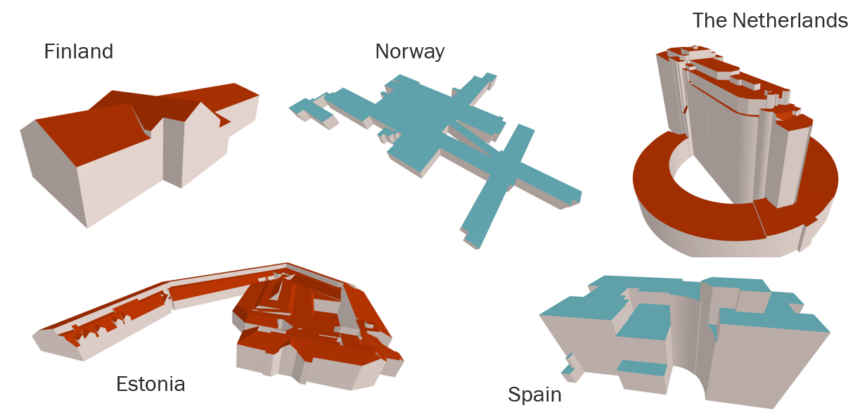
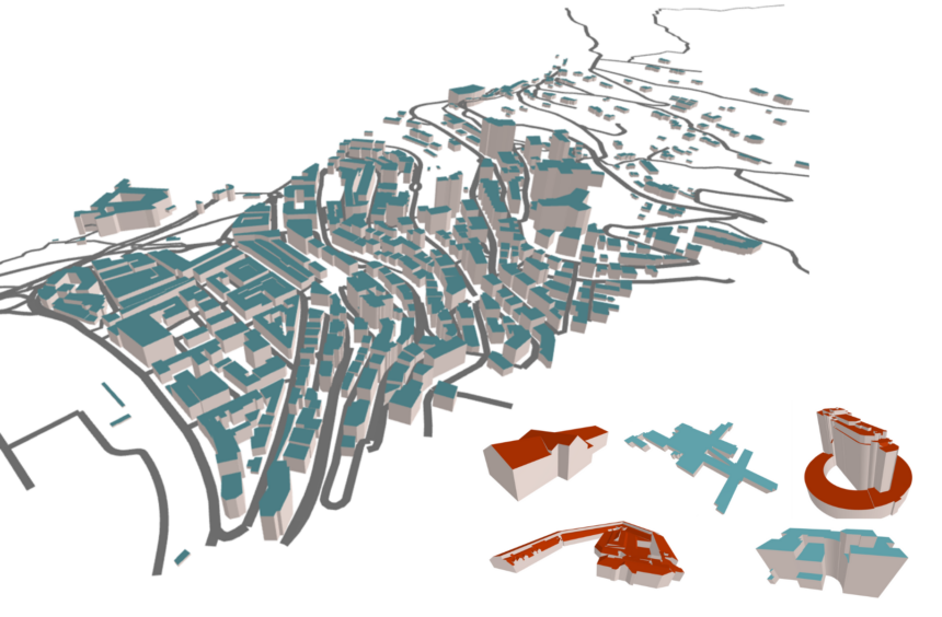
Extensions to Buildings Provision in GeoE3
With the recent additions to the Buildings/3D Buildings themes on the GeoE3 Integration Platform, the building’s theme has become the most populated theme in GeoE3. Currently, there are seven countries covered in the 2D Buildings theme and eight countries in the 3D Buildings theme. The new countries added to the GeoE3 Integration...

Develop your data and service integration skills
Do you find it challenging to integrate data from different sources? Are you looking for ways to streamline your data integration processes and enrich your data? Look no further than our new “Data and Service Integration” course at the Location Innovation Academy. Our comprehensive online course is designed to teach you the latest...