
Extensions to Buildings Provision in GeoE3
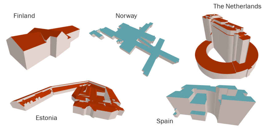
With the recent additions to the Buildings/3D Buildings themes on the GeoE3 Integration Platform, the building’s theme has become the most populated theme in GeoE3. Currently, there are seven countries covered in the 2D Buildings theme and eight countries in the 3D Buildings theme. The new countries added to the GeoE3 Integration...

Develop your data and service integration skills
Do you find it challenging to integrate data from different sources? Are you looking for ways to streamline your data integration processes and enrich your data? Look no further than our new “Data and Service Integration” course at the Location Innovation Academy. Our comprehensive online course is designed to teach you the latest...

Interested in new technologies of data services?
Do you want to stay ahead in the field of geospatial technology? Are you interested in learning about the latest OGC API standards and how they can help you optimize your services? If yes, this online Data Service Management course is for you! In this post, you will learn about the course content and how […]
Interactive visualisation of 3D Buildings
In the last weeks, GeoE3 has been working to develop an integration platform by introducing datasets and functionalities for the 3D visualization of buildings. Access was given to the first test dataset of 3D buildings from a limited are in the South-Eastern region of Finland as well as a 3D buildings dataset from Estonia with complete...
A European undertaking for the effective use of geospatial data
Launched at the end of 2020, the Geospatially Enabled Ecosystem for Europe (GoeE3) project aims to improve the accessibility and interoperability of geospatial data. The project will cover various areas that have not previously been tested in the geospatial data sector. One of the goals of the GeoE3 project is to develop...
GeoE3 Service Architecture
Geospatially Enabled Ecosystem for Europe, GeoE3, is a project co-financed by the Connecting Europe Facility of the European Union that will provide the vital connection between existing and emerging National, Regional and Cross-Border digital services. The action provides dynamic integration of high-value data sets and services (e.g.,...